My property
Search an address, use the swipe tool or download a site report.
The proposed Caloundra and Surrounds Local Plan Area (LPA) is located in the south-eastern part of the Sunshine Coast. It includes the established communities of Caloundra, Kings Beach, Shelly Beach, Moffat Beach, Dicky Beach, Battery Hill, Currimundi, Aroona, Little Mountain, the southern part of Meridan Plains, Corbould Park, Caloundra West, Golden Beach and Pelican Waters and the large emerging community of Caloundra South (Aura).
Click on the coloured dots in the map below to see some of the proposed planning scheme changes specific to the Caloundra and Surrounds Local Plan Area (LPA).
These coloured dots give a short summary of some of the proposed changes, including land use, building height and minimum lot size. Not all proposed changes can be shown on this map and you are encouraged to find out more.
Caloundra South (Aura) will continue to accommodate greenfield growth as a priority development area. There are opportunities for redevelopment and revitalisation around the town centre of Caloundra with proximity to employment, services, community, sport and recreation facilities and the potential for heavy rail and high frequency public transport. Constraints to further development include flooding, coastal hazards, bushfire, steep and unstable land, native vegetation, current transport infrastructure capacities, and major electricity infrastructure.
From current Planning Scheme
From existing on-ground situation
The Sunshine Coast is included in the State Government’s South East Queensland Regional Plan 2023 (SEQ Regional Plan). This plan includes an Urban Footprint, which outlines the State Government’s preferred location for our region’s future urban development. The proposed planning scheme also encourages compact urban growth near jobs, services, entertainment and recreation, connected by existing and planned high frequency public transport.
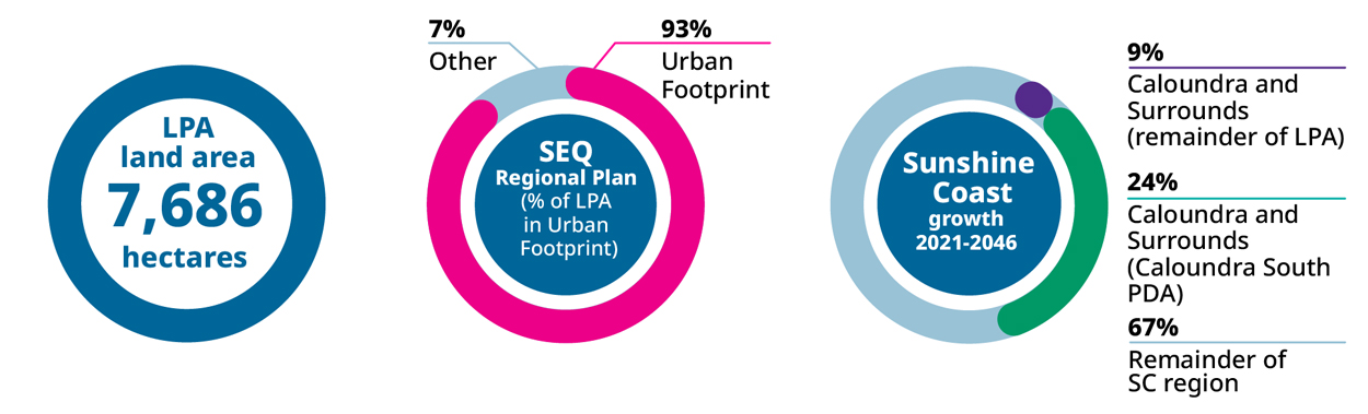
Explainer: This infographic shows how forecast population growth for the Sunshine Coast may be shared across the region by local plan area. These estimates are based on the proposed planning scheme zones and height limits.
Go to the My property Have your Say webpage to:
View the proposed planning scheme text and interactive mapping in ePlan, including the Caloundra and Surrounds Local Plan.
Read the proposed planning scheme supporting information sheets.


