My property
Search an address, use the swipe tool or download a site report.
The proposed Beerwah - Landsborough Local Plan Area (LPA) is situated in the southern part of the Sunshine Coast west of the Bruce Highway. It is centred around the communities of interest of Beerwah and Landsborough. Peachester, Mount Mellum, Crohamhurst and Booroobin are also located within the LPA. The LPA includes the Beerwah East South East Queensland Development Area (which is yet to be developed), the major tourist attraction of Australia Zoo and substantial poultry farms around Beerwah.
Click on the coloured dots in the map below to see some of the proposed planning scheme changes specific to the Beerwah - Landsborough Local Plan Area (LPA).
These coloured dots give a short summary of some of the proposed changes, including land use, building height and minimum lot size. Not all proposed changes can be shown on this map and you are encouraged to find out more.
Other than the Beerwah East SEQ Development Area, there are limited opportunities for further growth in the local plan area due to the need to protect agricultural land and rural activities, and physical constraints including steep and unstable land, and bushfire.
From current planning scheme
From existing on-ground situation
The Sunshine Coast is included in the State Government’s South East Queensland Regional Plan 2023 (SEQ Regional Plan). This plan includes an Urban Footprint, which outlines the State Government’s preferred location for our region’s future urban development. The proposed planning scheme also encourages compact urban growth near jobs, services, entertainment and recreation, connected by existing and planned high frequency public transport.
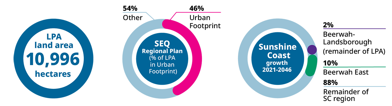
Explainer: This infographic shows how forecast population growth for the Sunshine Coast may be shared across the region by local plan area. These estimates are based on the proposed planning scheme zones and height limits.
Go to the My property Have your Say webpage to:
View the proposed planning scheme text and interactive mapping in ePlan, including the Beerwah - Landsborough Local Plan.
Read the proposed planning scheme supporting information sheets.


