My property
Search an address, use the swipe tool or download a site report.
The proposed Nambour and Surrounds Local Plan Area (LPA) is in the central part of the Sunshine Coast, mainly west of the Bruce Highway. It is centred around the community of interest of Nambour. Localities within this local plan area also include Highworth, Coes Creek, Burnside, Perwillowen, Towen Mountain, Image Flat, Parklands, part of Rosemount and the industrial area in the western part of Bli Bli.
Click on the coloured dots in the map below to see some of the proposed planning scheme changes specific to the Nambour and Surrounds Local Plan Area (LPA).
These coloured dots give a short summary of some of the proposed changes, including land use, building height and minimum lot size. Not all proposed changes can be shown on this map and you are encouraged to find out more.
Nambour is an established centre with a hospital and health precinct, a growing entertainment industry, established neighbourhoods and rich heritage. In this local plan area, there are opportunities for further growth and development both in the town centre and residential areas.
From current planning scheme
From existing on-ground situation
The Sunshine Coast is included in the State Government’s South East Queensland Regional Plan 2023 (SEQ Regional Plan). This plan includes an Urban Footprint, which outlines the State Government’s preferred location for our region’s future urban development. The proposed planning scheme also encourages compact urban growth near jobs, services, entertainment and recreation, connected by existing and planned high frequency public transport.
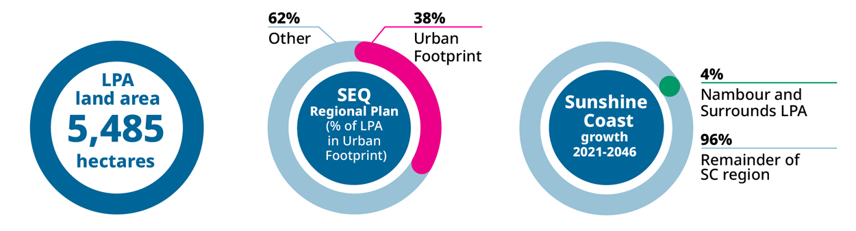
Explainer: This infographic shows how forecast population growth for the Sunshine Coast may be shared across the region by local plan area. These estimates are based on the proposed planning scheme zones and height limits.
Go to the My property Have your Say webpage to:
View the proposed planning scheme text and interactive mapping in ePlan, including the Nambour and Surrounds Local Plan.
Read the proposed planning scheme supporting information sheets.


