My property
Search an address, use the swipe tool or download a site report.
The proposed Mary Valley - Kenilworth Local Plan Area (LPA) is located in the western part of the Sunshine Coast. It is centred around the township of Kenilworth and also includes the localities of Conondale, Elaman Creek, Obi Obi, Cambroon, Kidaman Creek, Coolabine, Gheerulla, Belli Park, Conondale and parts of Wootha and Curramore. The area comprises primarily rural and conservation land.
Click on the coloured dots in the map below to see some of the proposed planning scheme changes specific to the Mary Valley - Kenilworth Local Plan Area (LPA).
These coloured dots give a short summary of some of the proposed changes, including land use, building height and minimum lot size. Not all proposed changes can be shown on this map and you are encouraged to find out more.
In this local plan area, there are limited opportunities for growth due to flooding, the need to protect productive agricultural land and major habitat, biodiversity and conservation areas, the need to maintain water quality in the Mary River catchment and distance to major centres and services.
From current Planning Scheme
From existing on-ground situation
The Sunshine Coast is included in the State Government’s South East Queensland Regional Plan 2023 (SEQ Regional Plan). This plan includes an Urban Footprint, which outlines the State Government’s preferred location for our region’s future urban development. The proposed planning scheme also encourages compact urban growth near jobs, services, entertainment and recreation, connected by existing and planned high frequency public transport.
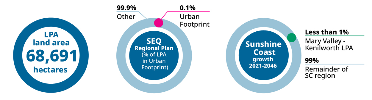
Explainer: This infographic shows how forecast population growth for the Sunshine Coast may be shared across the region by local plan area. These estimates are based on the proposed planning scheme zones and height limits.
Go to the My property Have your Say webpage to:
View the proposed planning scheme text and interactive mapping in ePlan, including the Mary Valley - Kenilworth Local Plan.
Read the proposed planning scheme supporting information sheets.


